
It's impossible to describe all the delights and beauty of the Himalayas; it's easier to see them. I'll just say that this magical place changes people mentally and physically.
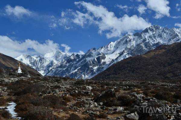
Langtang is a mountainous region in northern Nepal bordering Tibet. The local villages are populated by ethnic Tibetans who fled the bloody Chinese Communist occupation of Tibet several decades ago. Most of them are very welcoming and engaging people with Mahayana spiritual traditions.

We arrived in Kathmandu late in the evening and checked into a guesthouse in the Thamel area, the same one where we stayed last year.
That morning, during breakfast, we met two American trekkers; it turned out they were also going to Langtang. That's how our group spontaneously began to form.
After breakfast, we went to pick up our trekkers' books (TIMS) and permits at the Tourist Service Center (some call it the Nepal Tourism Board). It's a 15-20-minute walk from Thamel; it's a large brick building on the corner of Durbar Marg and Pradarshani Marg. The Tourist Service Center is open weekdays from 9:00 AM to 5:00 PM, and on weekends, I think, until 1:00 PM, but I'm not sure (we picked them up on a weekday, a Friday). You'll need to bring four 3x4 photos.
The permits have been received, after which we can go for a walk.
Tomorrow morning we set off for Langtang! Day 1. KTM — Syabrubesi (1450) — Tholo Syabry (2200). At 5:20 a.m., the whole group piles into a tiny car (we arranged this at reception the night before) and for 200 Nepalese rupees we reach the bus station (if memory serves, Gongabu Central Bus Terminal). Amidst the typical Asian chaos, we finally find a local bus departing for Syabrubesi (Langtang) at 6:30 a.m. — this is why you need to arrive early. The cost is approximately 300 rupees per person.
Local buses in Nepal and India are a unique experience! Those who know will understand, and those who don't should try it. Seven to eight hours of local flavor, vigorous shaking, and sitting on and under backpacks, boxes, and crates. The last quarter of the journey is especially "good"—it's so shaky you have to hold on to the battered seats. But the views from the window are truly worth it! The bus makes short stops periodically, allowing you to stretch your legs and buy something to eat from local vendors.
We arrive in Syabrubesi at lunchtime, have a snack, and set off on the trek around 3:00 PM. The Langtang trek can be started on either the right or left side of the river. We took the right side.
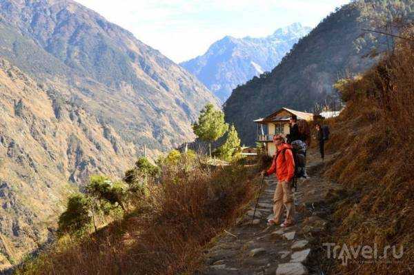
By evening, we reached the village of Tholo Syabry. The overall mileage wasn't great, but the elevation gain was from 1,500 to 2,200 meters, so we walked for a long time and arrived after dark, very tired. The Americans were slightly ahead of us, and by the time we approached the village, we were already met by the owner of the house where our American comrades had settled in for the night. Speaking decent English, he greeted us, said they were starting to get nervous (it was getting dark), and praised his wife's cooking, which we were about to try.
The house turned out to be very decent, made of stone. Even the shower and toilet in the house—the bathroom has cold running water (hot water is provided separately in a bucket)—a rarity in those parts. Of course, it's cold to wash—the floor is cement, there's no heating, and drafts blow through every crack. However, overall, these are very comfortable conditions for such a trek.
They didn't charge for the room itself, but they did charge for the food. The hosts have a small "menu" in English especially for trekkers. The dishes are simple but VERY tasty (curry rice, lentil soup, homemade vegetable pies). There's no meat or fish—well, I was just glad.
You need to sleep dressed warmly and wrapped in a sleeping bag, because the Himalayan night, you know, is not kind!
Day 2. Tholo Syabry (2200) - Bamboo (1950)
Travel time (including photo stops, rest, and lunch) is 7 hours. In the morning, invigorating cold water treatments, breakfast, farewell to the hospitable host, and off we go.
It's incredibly interesting to observe how nature changes with every thousand meters gained or lost. At altitudes of up to 2,000-2,500 meters, dense vegetation, including rhododendron and bamboo thickets, is abundant. Later, as we approach Langtang and beyond, we'll notice that nothing grows there at all, so we have to collect firewood for heating much lower down and then haul it up.
Anyway, back to the road from Tholo Syabry to Bamboo. We're moving briskly, stopping occasionally to rest, grab our packed lunch, and drink some water (we stocked up on it at Tholo Syabry).
We reached Bamboo by five o'clock in the evening. We'd originally planned to continue on, but it would soon be dark, and we were very tired, so we stopped in this village with yet another group of hospitable hosts.
A pleasant encounter awaited us here—we'd met a Japanese couple on the bus from Kathmandu. We'd parted ways as we exited the bus, wished each other luck, and then finally met! It turned out they'd spent the previous night in Syabrubesi, and today they'd run the entire day from Syabrubesi to Bamboo, without the climb up to Tholo Syabry.
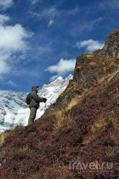
Mountain romance. American comrades resting after a day's hike:
Here, by the way, I tried a "real Himalayan shower"—a wooden cabin (like our summer showers), a bucket of hot and a bucket of cold water with a ladle, and all this with a view of the mountains! Gorgeous! Just be quick, because it's cold.
The evening was international and interesting—everyone, including the hosts, gathered in the kitchen-living room, chatting about everything under the sun. It turned out the school was quite far away, so the hostess doesn't take the children there, but teaches them herself. Sometimes, passing trekkers tutor the children in English.
Then we all chanted mantras together, and Janis played the harmonica. I tried to film it, but without electricity it didn't work out well. We ended the get-together with a game of Scrabble—the Americans had everyone beat, of course! Day 3. Bamboo (1950) — Gumnachok (2700)
Travel time (including stops for photos, rest, and lunch) is 7 hours. The morning was cloudy.
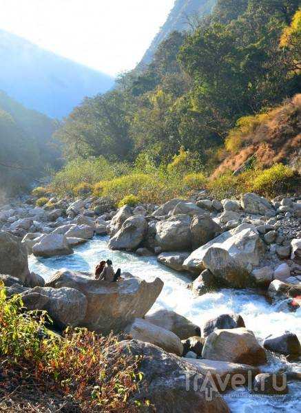
We reached the bridge over the river fairly quickly, but then the steep climb began. Occasionally, cattle drivers and donkey porters would come up behind us or toward us, and we had to give way. The Japanese ran ahead.
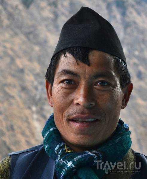
Having finally gained about 500 meters in altitude, we found ourselves near Rimche, a small village of three or four houses. A woman of typical Tibetan appearance was cleaning the porch of one of them. Langtang is home to many Tibetans who fled Chinese expansion; native Nepalese look slightly different from Tibetans, but after wandering around Nepal for a while, you begin to discern their ethnicities. So, at our request, the woman baked us a couple of flatbreads and served them with honey and tea. This "lunch" for one costs about 300-400 Nepalese rupees (approximately 120-160 rubles).
In general, when it comes to food on the trek, you don't have to carry provisions to Langtang; you can eat in the guesthouses where you stay—it's convenient and inexpensive. However, it's essential to bring a packed lunch for snacks throughout the day, as settlements are rare, and the strenuous activity of a trekking day takes its toll.
Sometimes we meet other trekkers on the road – mostly Europeans and Americans, no Russians in sight.
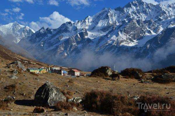
We set up camp at 5:00 PM in Gumnachok—frankly, it's the only house in this village marked on the map. The wooden house sits right on the bank of a mountain river, so it's definitely chilly at night, even with thermal underwear and a sleeping bag. Day 4. Gumnachok (2700m) — Langtang (3300m)
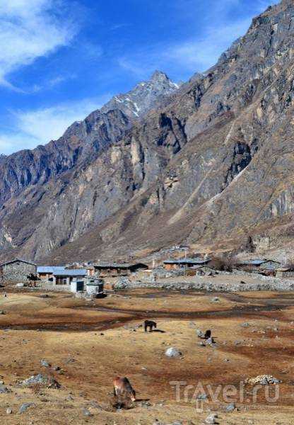
Travel time (including short stops) is 5 hours. We'll depart in the morning for Langtang. The high-mountain village of Langtang is the largest settlement in the Langtang region. It was here that refugees from Tibet settled, continuing to uphold the traditions and venerating the Mahayana Buddhist path. However, Mahayana is divided into four distinct schools, the main and most famous of which are the Gelugpa (Yellow Hat) school and the Nyingma school. Portraits of representatives and spiritual teachers of these schools are carefully preserved in the "red corner" by the residents of Langtang.
Many people finish their trek in Langtang and turn back, but we knew that the next day we would go even further.
We arrived in Langtang at lunchtime, and the 4.5-hour drive had left us exhausted—the constant climb, the bright sun, and the strong mountain wind—that's exactly the combination that turns your lips and skin into rags in just a few hours.
That evening, while strolling through the village, we came across a celebration taking place in one of the houses. Locals sat around an invited lama, who recited mantras and beat drums. At a certain point, everyone present had to throw rice into the fire (as I realized, this is analogous to the Hindu yagya, a ceremony to attract good luck and prosperity). Then the host treated everyone to homebrew—something strange, slightly alcoholic, with a pleasant fruity flavor. Day 5. Langtang (3300) — Kyanjin Gompa (3700)
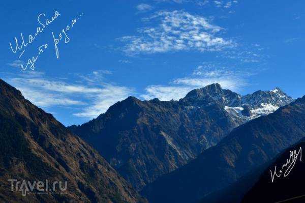
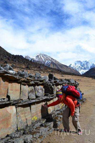
Travel time (including stops for photos and snacks) is 4 hours. One of the most beautiful and interesting transitions on the entire trek.
We walked slowly, enjoying the beautiful views and all sorts of finds (for example, these manuscripts on stones):
In the evening, we met some Japanese at a guesthouse. The house was new, made of stone. But it was very cold—which is not surprising, as walking at such an altitude without hats and gloves is simply impossible. There is no vegetation, except for grass. At night, the temperature drops to -5…-10°C. Further up, there are no settlements at all. Tomorrow we will ascend Kyanjin Ri and descend. Day 6. Kyanjin Gompa (3,700m) — Kyanjin Ri (4,300m) — Kyanjin Gompa (3,700m)
The total time for the radial hike (round trip, including breaks and photos at the summit) is 6 hours. A wonderful morning in the mountains, surrounded by these mighty white peaks:
The morning is cold, with some snow on the ground. As the sun rises, it gets warmer, but the wind is merciless.
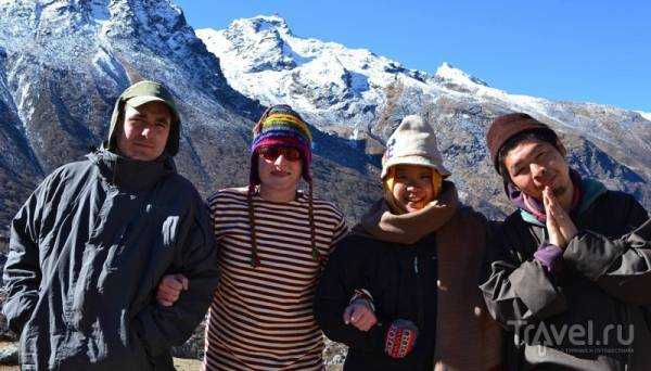
After breakfast we take photos with our Japanese comrades:
Then we set out on a radial hike. We need to have time to climb Kyazhing Ri, enjoy the views there, and then descend back. We're traveling light, securing ourselves with alpenstocks for safety. The slope is very steep in some places! You especially need to be careful on the descent, traverse carefully, and take your time—otherwise, you could end up falling so badly you won't be able to collect your bones.
The climb took about three hours. The sun was blazing, the wind was biting. I deeply regretted not bringing a face mask. In the last third of the way, my breathing began to fail me—the air was thin, the climb was steep, and in some places there was a trail, in others there was none.
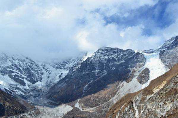
All the hard work is rewarded at the summit. It's a blast! The views from there are as follows:
The descent took about an hour and a half. We descended carefully, using alpenstocks for protection, but quickly—we were desperate for something to eat and warm ourselves by the fire. Day 7. Kyanjin Gompa (3,700m) — Lama (2,450m)
Travel time (including photo stops, rest, and lunch) is 9 hours. We bid farewell to this beautiful place and head back. We set off around 9 a.m. and by 11 a.m. we're in the village of Lagtang. A light snack, followed by a nearly six-hour trek to Lama. The descent is much easier, and the return journey becomes much easier. Around 6 p.m., we camp for the night in Lama.
By the way, this is how firewood is transported to the highlands:

Day 8. Lama (2450) — Sherpagon (2500)
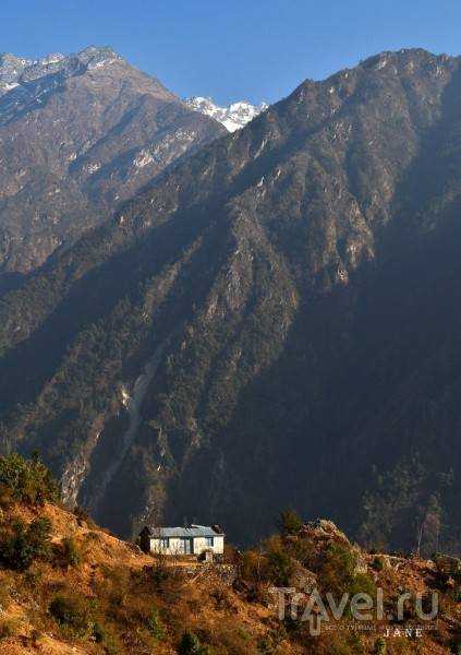
The journey time (including frequent stops due to poor health) is 3-4 hours. We decided to return along the opposite bank. Sherpagon is located almost opposite Bamboo, on the opposite bank of the river, but significantly higher, so the views are magnificent! At the same time, there are plenty of trees here and there is no piercing wind. Sherpagon is a small village of about five houses.
Here I had the chance to see how the locals dry meat, which was surprising, because in general in that area people hardly eat meat.
In general, the transition from Lama to Sherpagon is quite simple and quick; you can walk in one day from Lama to Syabrubesi (the starting and finishing points of the trek, the bus station), but due to the fact that I had a cold and felt terrible, I barely trudged to Sherpagon for about 3 hours, and I had no strength at all for the further journey.
But in Sherpagon you can enjoy the last evening and night in this beautiful Himalayan valley, the absence of civilization, roads and bustle.
Day 9. Sherpagon (2500) – Syabrubesi (1450)
Travel time (including stops for photos, rest, and lunch) is 8 hours. My health improved significantly in the morning (those liters of masala tea I drank were worth it).
The road is pleasant and fairly easy; it is hot, but there is an opportunity to hide in the shade of the trees.
Just before Syabrubesi there is a fairly steep forty-minute descent.
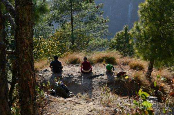
We met people meditating:
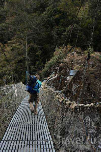
We cross the suspension bridge and take a last look at the river's turn towards the Langtang Valley - oh, that was a wonderful trek!
So, after six leisurely hours of walking, we reached Syabrubesi. At this point, it feels like you're practically in a metropolis: a paved road, passing cars and mopeds, groups of children in school uniforms, and even a guesthouse with Wi-Fi! Day 10. Syabrubesi — KTM
At 7 a.m., we pile into a battered local bus and jolt along the road to Kathmandu. The first hour and a half are especially brutal—the road is steep and narrow, and the bus sways so much that everyone and everything inside is periodically thrown around. And hello, "my dear Kathmandu!"
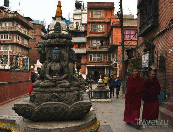
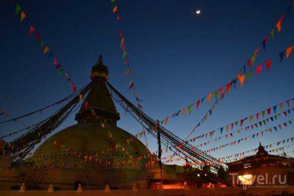
We spent the next 3 days mainly in the Bouddhanath area:
Source: travel.ru